Our changing climate is bringing new risks which bushwalkers and outdoor adventure enthusiasts should keep in mind whenever planning trips, and whenever we head out on our adventures.
This page gives a quick summary of what to consider. Click through to the relevant authority for detailed information, alerts and to subscribe to alerts and news from each authority.
Extreme weather
The consequences of our changing weather are:
- More National Park/State Forest/etc closures + more track closures – due to:
- Threat of fire
- Damage from fire/flood making tracks unsafe and/or impassable
- Dehydration & heat stroke of greater concern in hot summer days
- Increased chance of flooding
- Poor air quality making prolonged exercise inadvisable (see below)
- A new Fire Danger Rating
That is why it is important for you to check conditions before you head out. Also monitor conditions for rapid changes. For example, on high fire danger periods/days, or during extreme rainfall, etc.
Avoid remote areas during bushfire conditions. Look at the forward forecast fire ratings and weather before multi-day trips and err on the side of caution.
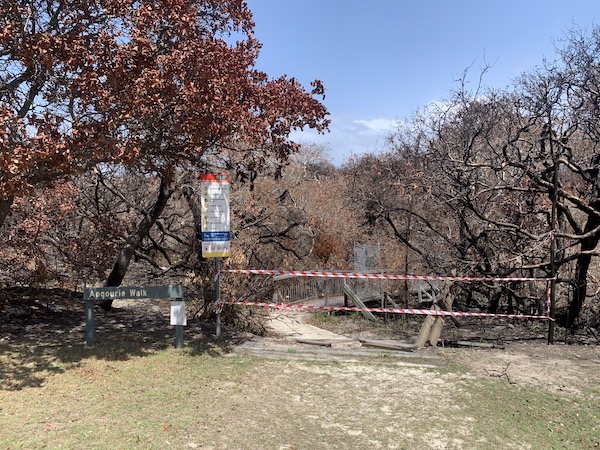
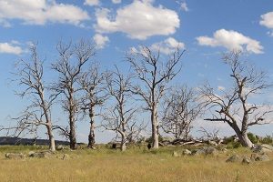
National Parks closed and damaged by fire
Air quality & health
Air pollutants, including smoke from bush fires, can be harmful to our health and so check air quality forecasts before you head out.
NSW Department of Planning, Industry and Environment states that we should all reduce heavy or prolonged exercise when the Air Quality Index (AQI) is >150.
However, The Climate and Health Alliance have now declared: “There is no safe level of air pollution. The higher the level of pollution, the more hazardous the risks to health. Bushfire smoke is particularly hazardous because of the high levels of tiny particles (PM2.5).”
You can check the current and forecast air quality here: https://www.environment.nsw.gov.au/aqms/aqi.htm
And find out what the AQI colours mean for your activity here:
https://www.health.nsw.gov.au/environment/air/Pages/aqi.aspx
Leaders should cancel activities to areas likely to be affected by poor air quality.
Fire Ratings
Note that a new Bush Fire Danger Rating exists called “Catastrophic”. If a Catastrophic warning is issued when and where you are planing to be in the bush, you should cancel your planned activities and move to a place of safety.
A “Catastrophic” rating may be issued in advance so always check the forecast if you are planning/heading out to a multi-day activity.
The current RFS advice for what you should do if the Bush Fire Danger Rating is “Catastrophic” is:
- For your survival, leaving [the area to be affected] early is the only option.
- Leave bush fire prone areas the night before or early in the day – do not just wait and see what happens.
- Make a decision about when you will leave, where you will go, how you will get there and when you will return.
- Homes are not designed to withstand fires in catastrophic conditions so you should leave early.
See the RFS for full details of Bush Fire Danger Ratings including “Catastrophic”: http://www.rfs.nsw.gov.au/fire-information/fdr-and-tobans?a=1421
Learn more about Bush Fire Danger Ratings and Total Fire Bans here: https://www.rfs.nsw.gov.au/fire-information/fdr-and-tobans
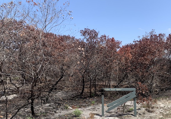
Fire damage
Every time you head out – check:
To manage these hazards always check before you head out:
- Land managers’ Alerts:
- ie: National Parks & Wildlife Service, State Forests, Crown Lands, Council, LiveTraffic, etc
- For:
- park/track/road closures and
- impacts of fire/flood/cyclone/snow
- Weather: http://www.bom.gov.au
- Check forecasts for: Temperature, Wind, Rain, Streamflow Forecast, Tides, Waves
- Check warnings for: Fire, Flood, Cyclone, Heatwave Assessments, Marine, Coastal, Surf
- Fire: http://www.rfs.nsw.gov.au
- For: Fires near you, Fire danger ratings & Total Fire Bans, Planned hazard reductions
- Other tools for monitoring fires include:
- Air quality: https://www.environment.nsw.gov.au/aqms/aqi.htm
Hot Spots
These new tools may indicate fire activity, however the site creators say they are “not to be used for safety of life decisions. For local updates and alerts, please refer to your state emergency or fire service.”
Always remember, that this information is only as updated when a satellite passes over the location you are viewing. IE: not that often.
https://firewatch-pro.landgate.wa.gov.au/ (seems to be more current just from our casual observation)
https://hotspots.dea.ga.gov.au/
Alerts
- Bushwalking NSW does not pass on alerts. Instead, we recommend you sign up for alerts directly with the relevant authority
- Bushwalking NSW periodically remind our newsletter subscribers that people and clubs should check for alerts:
- In anticipation for activities
- Before they head out
- Sign up to our newsletter at the bottom of this page and here
Subscribe to updates
- We encourage all people engaged in outdoor adventure to sign up to receive alerts from the relevant authorities.
Clubs
- We suggest clubs consider how they are communicating with their members when conditions become hazardous or extreme.
We hope this brief guide helps you all to continue to enjoy safe and successful outdoor adventure in our beautiful natural places!