Nothing dollarable is safe, however guarded.
What was true in the USA in 1909, when legendary American conservation crusader John Muir wrote those words, remains equally true in Australia in 2023. As proof, look no further than the suite of developments and proposals for tourism development in protected areas multiplying throughout the national parks estate. The race to commercialisation in some of our protected places has become a vexed issue.
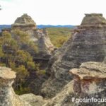
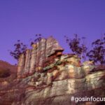
The popularity of Tasmania’s Three Capes Walk has had mainland state bureaucracies salivating at the prospect of emulating the feat, even though there’s no telling whether it is actually making money for Tasmanian Parks and Wildlife. Commercial-in-confidence provisions in the relevant leasing and licensing contracts see to that. The ‘iconic walk’ fairy dust is now being sprinkled liberally all over the place. And with the iconic walk sobriquet invariably comes the business case pressure to commercialise and privatise in some way.
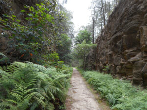
Thus we have the Australian Walking Company succeeding in its proposal to build eco-pods in the Flinders Chase National Park on Kangaroo Island, in which to house its guided walking clients on the 5-day Kangaroo Island Wilderness Trail. Expect to pay around $800 per night per person for the privilege. In this case the word ‘wilderness’ is something of a marketing tool but there have been serious proposals by such companies to build luxury accommodation in more remote designated wilderness areas: an unsolicited (and unsuccessful) proposal to do so on the Kanangra to Katoomba (K to K) walk through the Kanangra-Boyd and Blue Mountains Wilderness areas a few years ago springs to mind.
Such proposals are concocted, oblivious to the fact that the phrases ‘wilderness lodge’ ‘wilderness resort’ or even ‘wilderness hut’ are all oxymorons. But most of our national parks are not declared wilderness and the legal restraints that apply are fewer.
In coastal southern Queensland, there’s a proposal to build 10 ‘eco’ huts sixty metres up the banks of perched Poona Lake near Rainbow Beach in Great Sandy National Park to facilitate commercial guided walking on the Cooloola Great Walk. This national park also encompasses k’gari (Fraser Island); it’s only k’gari’s protection as a world heritage site preventing such development there.
Meanwhile, Victoria has come up with the Falls to Hotham Alpine Crossing that will stretch an overnight backpack walk into a 5-day, 57-kilometre affair at the cost of many tens of millions of dollars. The consequent ‘low impact’ huts (with up to 10 two or three-person huts, a communal hut and two toilets at each site, this is more akin to a mini mountain village) are to be built at taxpayer expense but not available to the independent walker: the ‘preferred model’ is to lease them to a single private operator who would also operate the high-end accommodation and guided hiking package at around $800 per night.
Parks Victoria has already set its own precedent with the huts it had constructed at two walk-in campsites along the northern section of the new Grampians-Peaks-Trail. You can stay in these 4-person eco-huts so long as you employ the guiding and cooking services of either the Grampian Peaks Walking Company or Raw Travel and sign up for a 3-day guided walk: expect to pay around $900 each per night. When not being used by the two commercial operators (that is, most of the time), the huts lie unoccupied.
New South Wales has come late to the party but is busily making up for lost time. First up on the far south coast, the controversial Light to Light Walk upgrade, featuring two new huts. An earlier version of the proposal, modified after a public backlash, excluded independent walkers from camping at certain scenic sites and sought to force them to camp at the existing and less salubrious drive-in camp sites. The stay at the Green Cape lighthouse at walk’s end will be available exclusively to Light to Light walkers and will no doubt be bulk booked by commercial operators who will likewise seek access to the new huts on a bulk-booked basis.
At $56 million, the 4-day Dorrigo Escarpment Great Walk will also have 3 new (basic) huts and campsites and a swish new Rainforest Visitor Centre. It is unclear whether it will be publicly managed or not: the department website states, ominously, that detailed operational procedures and pricing are not yet provided.
No such ambiguity with the proposed Great Southern Walk between Kurnell and Sublime Point. This 67-kilometre walk traversing Kamay Botany Bay NP, Royal NP and the Illawarra Escarpment State Conservation Area, is already open for Expressions of Interest to find a suitable delivery partner even though no new infrastructure has been built yet. Once the new huts and campsites are completed, the suitable partner will ‘help run the guided walking and manage the new camping experiences using the new facilities’: more outsourcing to a private operator on an exclusive basis. The rationale for this – and I quote – ‘it … allows us [NPWS] to get on with managing our visitors and conserving the natural and cultural values of the national park.’ [Department of Environment website]
Apparently, managing walkers’ huts and campsites isn’t considered by NPWS to be part of managing visitors. If NPWS lacks the expertise to do so it should be recruiting skilled staff because the ‘provision for sustainable visitor or tourist use and enjoyment…’ is one of the legislated management principles under which it operates. You can bet that if a guided-walks operator is managing the new huts, their clients will get priority or even exclusivity, with independent walkers relegated to the camping platforms.
For something far more egregious, look to the plans for the long awaited and recently created Gardens of Stone State Conservation Area (SCA). No sooner had it been declared than a draft Plan of Management was released for public consultation. The problem with this slimline document was it had almost nothing of substance in it. All detail of what is being proposed for the SCA – a veritable theme park in the park’s ‘Lost City’ area – was devolved to a separate document: a draft Master Plan for the delivery of $50 million-worth of eco-adventure tourism.
The problem (or, more cynically, the trick) is that the master plan is a non-statutory document – it doesn’t need to be adopted by the Environment Minister, nor would it require public consultation to alter it; it could be changed at will. Along with zip-line courses, a via ferrata rock scrambling course and 4WD touring routes, there will be the multi-day hut-to-hut Wollemi Great Walk. No doubt, the huts, to be built with taxpayer funding, will again be effectively privatised through a long-term lease to a ‘preferred operator’, an all-too-familiar trope.
There are other ways of operating such long-distance walks that are still compatible with the high-end market. You can walk Victoria’s popular Great Ocean Walk the luxe way, staying off-park each night at the same luxury walkers lodge (midway at Johanna, which is not part of the park) and being transported with your daypack each day to the trailhead. Similarly, WA’s Cape to Cape Walk can be done in guided luxury, staying at Margaret River.
Kosciuszko’s new 55-km, 4-day Snowies Alpine Walk between Guthega and Lake Crackenback (Thredbo River) will be able to be walked self-guided or guided but staying at existing infrastructure at Guthega, Charlotte Pass and Perisher. Close to home, Shoalhaven’s soon-to-open 34-km Murramarang Coast Walk can be walked pack-free and with a roof over your head, staying either off-park (operators are already advertising guided package deals) or on-park at pre-existing accommodation, for example the cabins at Pebbly Beach, Depot Beach and Pretty Beach. But with bureaucracies feeling the political imperative to monetise the national parks estate in return for the sudden windfall funding for tourist infrastructure, this model seems to be on the wane. Put simply, there’s not enough money in it.
The argument is inevitably made that guided hut-to-hut walks increase equity of access by enabling people to complete such walks who would not otherwise be able to do so. This may be true in theory but in practice, the high costs of such guided walks in Australia preclude the majority of people availing themselves of the opportunity.
I recently attended a full-day symposium organised by Bushwalking NSW on Tourism in Protected Areas and not surprisingly, several of these case studies were discussed. It’s fair to say there wasn’t a lot of love in the room for commercial enterprises seeking exclusivity or for National Parks management seeking to outsource responsibility for managing the assets that are, after all, publicly owned and taxpayer funded.
So what is a reasonable stance to take on these issues? There is a (hard)core of bushwalkers who decry any roofed accommodation and related infrastructure ever being built in our national parks. They would hold to the idea that only self-reliant and self-sufficient walkers have any place venturing there on multi-day excursions. This is not what I’m advocating here. I don’t have an in-principle problem with huts in our national parks – either pre-existing or newly-built – if they are truly low-key, sensitively placed and having a low environmental impact. Huts have a particularly valuable place in more hostile environments and I’ve slept in plenty over the years. It’s the model that’s the problem. Given that our national parks and other such protected areas are all public land (unlike, say, European national parks), my first objection is to any form of de facto privatisation: giving commercial entities exclusive long-term leases on public infrastructure or on land on which to build their own.
I don’t object to paying a (modest) premium for staying in a basic hut rather than using an associated campsite. But there should always be a choice. Nor do I object to commercial operators providing guiding, cooking, pack transportation, food drops, trailhead client transport and the like under an appropriate licensing agreement. But such arrangements should be transparent, contestable and nonexclusive and the financial details should not be shrouded in commercial-in-confidence.
My biggest objection is to any attempts to mandate the use of huts, private or public, as a precondition for undertaking a multi-day walk a la the Three Capes Walk template. At the end of his presentation at the above-mentioned symposium, I asked a very senior NPWS manager why the Green Gully track – a 65-km walk in the NSW Oxley Wild Rivers National Park – is off limits to tent-based walkers. Self-guided walkers are required to move each day between the 5 pre-booked, six-person huts for which solo bookings are not accepted. The cost, though a small fraction of comparable commercial guided walks, is considerably higher than the Overland Track. I got a sheepish reply that this walk’s overly prescriptive regulation is an aberration, a mistake not to be repeated. I fear otherwise. Thank you to Rob Blakers for Three Capes Accommodation Footprint images.
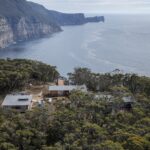
Three Capes 9/11/15
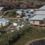
Three Capes 9/11/15