main

Author Archive | Jaimey Foti

BSAR Update

BUSH SEARCH AND RESCUE NSW Inc.

Keith Maxwell – President BSAR

Bush Search and Rescue NSW (BSAR) was founded as the self-help and self-contained “Search and Rescue Section” of the NSW Federation of Bushwalking Clubs in 1936 by Paddy Pallin plus a number of prominent bushwalkers of that time.  BSAR is held in high regard with NSW Police.  This report can only provide an overview of a very active volunteer rescue group.


THE BIG PICTURE.  In April of 2017 Bushwalkers Wilderness Rescue Squad (BWRS) changed its name to BSAR.  BSAR is a specialist remote area bush search and rescue squad affiliated with the NSW Volunteer Rescue Association (VRA). Some other specialist squads of the VRA includes NSW Cave Rescue, Australian Civil Air Patrol (AusCAP) and radio squads WICEN & CREST.  For more information see the VRA website at www.rescue.org.au


A YEAR of CHANGE.  After a long period of consultation plus a member vote BSAR has decided to change from affiliation with the VRA to become part of the NSW State Emergency Service (SES).  It is not just that BSAR is now in a stronger financial position.  An equal (major) consideration was the ability to better continue its role as a valuable community resource as a volunteer remote area search and rescue squad.  The volunteer s & r space is changing with changes in volunteering within SES.


A full changeover will take time with rebranding of our Rooty Hill building, new vehicles (& sale of VRA branded Toyota and trailer), new equipment, membership induction plus supply of uniforms etc.  Completion of the four stage process will continue into 2018 / 2019.


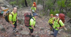
TRAINING.  BSAR has a strong membership and an active training program to assist completion of nationally recognised Competency Based Training (CBT).  CBT will now be progressively aligned to SES requirements.  Like all emergency services BSAR members must quantify their skills through CBT. Operational members are experienced bushwalkers with a mix of additional skills in radio communication, vertical rescue, observation, emergency management, First Aid and other bush search and rescue skills.


EQUIPMENT.  This change has given BSAR access to far greater resources and equipment.  A major change for BSAR will be access to “GRN” (Government Radio Network).  In various forms GRN attempts to link communications throughout all NSW government agencies from NP&WS to Police, RFS, NSW Ambulance etc.  Over time BSAR will receive new radios and appropriate training.     BSAR still has its existing, outstanding HF radio network.


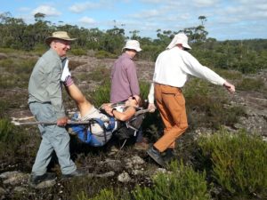
CALLOUTS.  During the past year BSAR was placed on STANDBY numerous times for incidents (with missing persons) that were quickly resolved.  However, in November 2017 assisted NSW Police at Katoomba to locate and retrieve the body of a visitor from France.  He had fallen over one of the big cliffs in the area.  In May, BSAR assisted in a forensic search near Ingar Picnic Ground, Wentworth Falls then in June BSAR was part of a large search at Mt Ku-ring-gai for a visiting Chinese student to Australia.  More recently the body was located some distance from the search area.


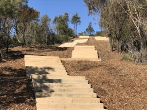
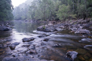
NAVSHIELD.  Warm days (but cold nights) made for an enjoyable NavShield 2018 on the last weekend of June.  NavShield is a major bush navigation (map and compass) training event for the Emergency Services and bushwalking club teams.  Renewed publicity within SES refreshed participant numbers to almost 500.  The location was dry woodland of the Macdonald River off the Putty Road.  Bushwalking club teams performed well.  Full details and results are available at the BSAR website – www.bsar.org.au


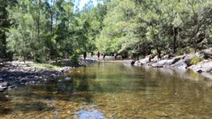
OXFAM TRAILWALKER.  TrailWalker in August each year has grown to become a 100km / 48 hour OR 50km / 24 hour track & fire road walkathon that uses bushland on the northern fringe of Sydney.  BSAR provides first and second safety response teams, over shifts, for this event of around 3,000 participants!!   TrailWalker provides both excellent member training and practice in co-ordination of BSAR teams whilst being involved in community outreach.  See the OXFAM website for route details of this special event – https://trailwalker.oxfam.org.au/sydney/trail/


BARRINGTON TOPS.  In September of recent years BSAR has also held a multi-agency training event to continue searching for a Cessna plane lost at night in bad weather of August 1981.  While many planes have failed to successfully fly over Barrington Tops, “VH-MDX” is the only plane whose location remains a mystery.


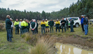
SAFETY ASSISTANCE.  During the year BSAR also provided safety assistance at several outdoors events including the Paddy Pallin Rogaine in June.


FIRST AID.  The current version of First Aid training offered by BSAR is very popular.  In 2018 THREE cycles of training will occur instead of the usual two.  Courses in the ONE Day St John Ambulance “Provide First Aid” (formerly known as “Senior First Aid”) OR three day “Remote Area First Aid (RAFA)” fill up quickly.  BSAR offers this training to spread First Aid knowledge generally among bushwalkers.  Training is bushwalker friendly with a volunteer bushwalker instructor plus a discount fee.  Register at the BSAR website.


In 2019 Bushwalking NSW will take over access to this First Aid training since BSAR cannot continue this model of instruction within SES.


OUTREACH.  BSAR is active through the digital world on its website with detailed information on bush safety, distress beacons, recent callouts and links to other sites such as the NSW Police TREK program of free PLB hire and BNSW (Bushwalking NSW).  BSAR is also active on FaceBook and Twitter.  Eventually, BSAR as part of SES will have to close its website – www.bsar.org.au  All options are being explored to continue digital dissemination of the above information.


MEMBERSHIP.  Membership of BSAR remains a valuable ‘fit’ for BNSW bushwalkers keen to volunteer their time in community service. We have tasks big and small to suit all levels of commitment.  Contact the BSAR Secretary at secretary@bsar.org.au


CONCLUSION.  BSAR with its great people and diverse events is held in high regard by NSW Police and now the SES for remote area search and rescue.  While it is a very different organisation to that founded in 1936 it is still committed to assisting persons in distress in remote areas.  2018 / 2019 will be a year of change as BSAR fully integrates into SES and explores the opportunities to better serve the community.  Access to GRN will enhance our remote area communications.  NavShield 2018 was a great event.  Other training was very successful. St John Ambulance “Provide First Aid” and “RAFA” courses offered via BSAR are very popular. BSAR is digitally active in encouraging bush safety.


Save Kosci

How to protest about feral horses – on your feet

Pounds Creek, Kosciuszko National Park, photo by M Bremers

In June, the NSW Parliament passed the Kosciuszko Wild Horse Heritage Act 2018. It gives an introduced species greater protection than native animals in Kosciuszko National Park – a disturbing precedent. With BNSW’s support, some member clubs have responded by setting up a new organization, Save Kosci Inc, to run a protest walk from Sydney to the summit of Kosciuszko.

The walk will take about 35 days, including rest days, from 3rd November to mid-December 2018. The main group of walkers will follow a mixture of major and secondary roads, via Camden, Mittagong, Goulburn, Canberra, Jindabyne and Charlotte Pass. The exact route is being surveyed now, looking at the walkability of the road verges and the availability of budget accommodation or camping en route.

Water source, crossing point, Bill Jones Hut Mar 2014

In addition to getting the Horse Heritage Act repealed, the aims of the walk are to:

  • Support a range of methods to control feral horses in NSW national parks, including ground-based lethal culling, under ranger supervision and according to RSPCA guidelines
  • Implement the NPWS Draft Wild Horse Management Plan of 2016
  • Protect the habitat of the broad-toothed mouse, corroboree frog and other native species affected by horses and other feral animals.

Save Kosci Inc is looking for these kinds of helpers:

  • End-to-end walkers
  • Section walkers – from a couple of hours to a couple of weeks
  • Support vehicle drivers and other non-walking helpers – from a day or two upwards; people with campervans, here is your chance to do a road trip for a Good Cause!
  • People to lead a walk for their club to the summit of Kosciuszko, from any direction, timed to arrive at the summit with the main walk (probably midday 8th or 9th December, to be confirmed)
  • Desk-based helpers, to do one-off research and writing tasks
  • People to sew banners
  • Photographers to record the walk, especially the first and last days, or to visit KNP to get close-ups of feral horses eating, drinking, trampling etc in KNP

Water source, crossing point, Bill Jones Hut, May 2018

A new web site for the walk is now running: savekosci.org, with a supporter registration form coming soon. If you are interested, please use that form to register; the form should be available online by late August. Registration costs $12. Inquiries welcome – to convenor@savekosci.org
Linda Groom, Convenor, Save Kosci Inc, 0473 919 441

Photos supplied by Linda Groom

A Concreted Coast

Central Coast Council approved a Master Plan for a permanent Walkway in March 2012 to provide a fully signposted concrete path which provides a safe route from Copacabana to Winney Bay, including a new north-facing and wheelchair accessible lookout at Captain Cook Lookout.

Concerned local Joy Cooper reached out to us recently concerning the concreting of the 5 Lands Walk in Winney Bay. She is not the only walker. Local residents are concerned about the damage done to ecological and cultural heritage of what was once a bushwalk track, now an 8 metre wide footpath that Joy Cooper describes as a ‘concreted coast’ that appeals more to tourists than walkers. As local walkers, bushwalking enthusiasts and trailblazers is there a line we draw when suggesting maintaining and improving tracks? We know it’s certainly something walkers can’t help wondering when seeing drastic changes on their favourite walk. Joy’s concerns below:

What a wonderful announcement from Adam Crouch with the huge sum of $4.6 million for his electorate, and for the Bulbararang cliff top walk.

What a shame the original plan for the walk had veered so far off the original plan. Having a bush-walk which makes it safer for walkers is wonderful and to link the two seaside village communities of Copacabana and Avoca Beach is superb. However to clear large areas of bushland to put in the walk way and concrete it, is a travesty and not needed, nor good practice.

If the current stairwell nearing completion is any indication residents will not be pleased. While residents were told in a community meeting the stairs were only 2 metres wide, the clearing of bushland has been more than 8 metres for more than 720 metres, and each week it is easy to see the clearing gets wider with more trees being damaged.

While machinery and fuel were to be kept in a compound on the old farm house site, sadly both were stored in bushland resulting in even more bush being cleared and damage occurring.

More than 60 trees were removed for this ‘nature walk’ for all to enjoy and remaining trees near the path were to have special protection to prevent any damage while construction was occurring, yet that did not happen and there have been numerous trees with damage and limbs torn off and thrown into the bush.

While the damage has occurred with the stairway to nowhere, despite numerous requests for it to stop before it was started, there was insistence by council for the stairs to be built, so the funding wasn’t lost. The cliff top ‘nature walk’ along Bulbararing is still to start. Residents should be concerned once again little or no information is made public until it is too late and the destruction has occurred.

While the original 2012 master-plan clearly shows the walk way through Winney Bay and along the Bulbarang cliff top is to be bush track and even shows images with no concrete to be seen, the current plans are nothing like that. The current plans are for a concrete pathway and vehicular access to market stalls, cantilevered cliff top platform for destination weddings along with a whale carcass shaped bridgeover a huge ravine which has very sorrowful memories for some in the community.

The original master plan mentions ‘existing areas of unique, intact native vegetation which high aesthetic appeal’ in Winney Bay and along the Bulbararing Headlands and there is mention of the need to keep the infrastructure ‘simple and discreet’. However the current plans in my opinion are nothing like that.

So, while we have a huge divergence from the original intention of the upgrade of the bush track and no consultation with the community, we also have the state government/Central Coast Regional Plan 2036/. With the second goal being to ‘Protect the natural environment and manage the use of agriculture and resource lands’. How we can do this and remove bushland by concreting vehicular access and concrete paths with large areas of batter doesn’t correlate for me.

Additionally, we have the recently adopted/ONE-Central Coast/adopted by Central Coast Council and the numerous mention of the need to protect our natural environment which is ‘cherished’. There is even mention of ‘expanding of the Costal Open Space System COSS’. Ironically, this Winney Bay area and Bulbararing cliff top are already part of COSS and there are numerous endangered ecological communities in the area.


What use are these documents if the powers that be can’t follow their own plans? What hope do we have of preserving bushland if it is degraded, neglected and then concreted? How can we connect to a place if it is all concreted?

Winney Bay and Bulbararing headland deserve the $4.6 million dollars which should be spent on employing trained people to rehabilitate the area and remove the bitou bush and harvest and grow local provenance vegetation, bringing back the natural beauty of the areaand providing the ‘bush track’ as originally intended. Not concrete creep and destruction.

Horse riding in wilderness areas

There is still opportunity for walkers to provide feedback on the proposed changes after trials of horse riding between 2014 and 2016 in parks managed by NSW National Parks and Wildlife Service (NPWS).

The amendments have been proposed to allow horse riding in wilderness areas, which includes 30km of the Nine Mile and Ingeegoodbee management trails in the Pilot Wilderness Area in Kosciuszko National Park, accessed via the Barry Way. The trial was from April 2014 to April 2016.

The public exhibition of these amendments has been available for comment since 22 June and will close 7 August 2018. You can also view the Horse Riding in Wilderness Trial Monitoring Program Final Report.

We urge Bushwalkers to make comment concerning the amendments particularly if you have walked in this area, your submission needs to be received by 7 August.

As per the guidelines:

Write clearly and be specific about the issues that are of concern to you.
Note which part or section of the amendment your comments relate to.
Give reasoning in support of your points – this helps avoid misinterpretation and makes it easier for us consider your ideas.
If you agree or support a particular part or idea in the amendment, please tell us.
If you disagree, please tell us specifically what you disagree with and why you disagree.
If you can, suggest solutions or alternatives to managing the issue.


Also note:

The proposed amendments can be viewed at https://engage.environment.nsw.gov.au/consult OR

  • OEH Customer Centre (Level 14, 59–61 Goulburn St, Sydney)
  • NPWS Narooma Office (corner Graham and Burrawang Streets, Narooma, NSW)
  • Braidwood Library (Park Lane, Braidwood, NSW)
  • Snowy Region NPWS Visitor Centre (46 Kosciuszko Road, Jindabyne, NSW)
  • Tumut NPWS Visitor Information Centre (5 Adelong Road, Tumut, NSW)
  • Cooma Visitor Centre (119 Sharp Street, Cooma, NSW)
  • Tumbarumba Visitor Information Centre (10 Bridge Street, Tumbarumba, NSW)
  • NPWS Walcha Office (188W North Street, Walcha, NSW)
  • NPWS Gloucester Office (59 Church Street, Gloucester, NSW)
  • Walcha Shire Council (2W Hamilton Street, Walcha, NSW)
  • Walcha Visitor Information Centre (29W Fitzroy Street, Walcha, NSW)

You can provide your submission in one of the following ways:

  1. use the online submission form at https://engage.environment.nsw.gov.au/consult
  2. email your submission to parkplanning@environment.nsw.gov.au
  3. post your submission Manager Planning Evaluation and Assessment, PO Box 95, Parramatta NSW 2124. 


Your submission will be provided to a number of statutory advisory bodies (including the relevant regional advisory committee and the National Parks and Wildlife Advisory Council). Your comments on the draft plan amendment may include ‘personal information’. OEH complies with the NSW Privacy and Personal Information Protection Act 1998, which regulates the collection, storage, access, amendment, use and disclosure of personal information. See OEH privacy webpage for details. Information that in some way identifies you may be gathered when you use our website or send us correspondence.

If an application to access information under the Government Information (Public Access) Act 2009 requests access to your submission, your views about release will be sought if you have indicated that you object to your submission being made public.

Stretcher Practice

Shoalhaven Bushwalkers had a first aid incident recently that resulted in some rather creative first aid practice involving a makeshift stretcher.

A short while into an off-track walk, one of their members ruptured his achilles tendon jumping between rocks.

After discussed diagnosis and plan of action, three members returned slowly with the patient, using borrowed walking poles, to the cars.

While waiting for the return of two of the walkers,  the remaining group decided to do a bit of first aid practice. Since there were no heavy duty rain jackets in the gear that day, they decided to try making a stretcher out of day packs.

As you can see, this was their successful result. In a real situation the packs could be emptied to lighten the load leaving a few soft items for support!

Photo: Karen Davis.

Warragamba Dam wall

If the Warragamba Dam wall is raised by 14 metres, the dam will hold over two additional Sydney Harbours, 4,700 hectares of World Heritage listed National Parks, 1,800 hectares of declared Wilderness Areas and 65 kilometres of Blue Mountains’ wild rivers would be inundated and destroyed.

It is arguably the most protected natural landscape in Australia. The Coxs, Kowmung, Kedumba, Natti, Wollondilly and Little Rivers would be flooded for months at a time.

Many of our Club members throughout NSW visit these areas.

Without our support, internationally significant environments that are recognised in the Blue Mountains World Heritage listing would die from sedimentation, erosion and invasion of exotic plants.

There are 48 threatened plant and animal species which inhabit the proposed inundation area.

Species such as the vulnerable Camden White Gum and the Kowmung Hakea are predominantly found within the inundation area, with the dam raising likely pushing many species close to extinction.


The area of proposed inundation is home to hundreds of Indigenous heritage sites.

Delicate rock art and marker sites will be forever destroyed if they are flooded by the raised dam for any length of time.

“Our history and our stories are in the landscape that surrounds Lake Burragorang. When Warragamba Dam flooded the valley in 1960, our lands and cultural sites were flooded. We do not want to see this story repeated with the remaining sites. Each time we lose a site, we lose part of our identity.”

– Kazan Brown

Gundungurra traditional owner and Warragamba resident


Information and photos courtesy of the Colong Foundation for Wilderness.

For more information, visit their website.

BUSH SEARCH AND RESCUE NSW TO JOIN NSW STATE EMERGENCY SERVICE

Bush Search and Rescue NSW​ have today announced that they have joined the NSW State

Emergency Service as the NSW SES Bush Search and Rescue Unit​ (NSW SES BSAR).

The move is an exciting development in the history of BSAR NSW, the oldest volunteer land

search unit in Australia, and will build on the existing land search capability within the SES.


With a focus on remote area searches, conducted in rough and challenging terrain, over 100

members of Bush Search and Rescue NSW will bring their knowledge and experience of working

in wilderness areas to the NSW SES. With expertise in bush navigation, search techniques,

canyon and vertical searching, BSAR will form an integral part of the SES’ response to land search

operations across the state.


President of Bush Search and Rescue NSW, Keith Maxwell says,

“Since 1936, BSAR has brought together experienced and skilled bushwalkers, many with valuable

local knowledge of wilderness areas, to assist the NSW Police and other agencies in searching for

missing people and aircraft. Our move to work as a unit within the NSW SES, will only go to

strengthen the existing relationships we have with the SES and help provide the best possible land

search and rescue capability to the people of NSW.”


The move comes at a time when the NSW SES is undergoing significant change to its structures

and organisation. These changes, spearheaded by their ‘Volunteering Reimagined’ initiative,

opens up new ways of building capability and capacity, within a new and flexible model of

volunteering.


“I am proud and honoured to welcome the Bush Search and Rescue into the NSW SES. The

BSAR volunteers will greatly enhance our Service’s remote search capability, bringing a wealth of

specialised experience with an excellent reputation. They are now very much a part of our NSW

SES family, and I look forward to them supporting search operations across the state.” Mark

Smethurst, NSW SES Commissioner.


NSW SES BSAR will operate as a unit within the SES and continue to be available to respond to

remote area land searches 24/7, as they have done under the umbrella of the Volunteer Rescue

Association (VRA), since 1970.


As hosts of the annual NavShield​ event (Australian Emergency Services Wilderness Navigation

Shield), BSAR are looking forward to the event sitting within the SES and continuing to grow the

training, development and team building opportunities that this premier navigation event offers.

For media enquiries, please contact: publicity@bsar.org.au | 0412 304 071 or

secretary@bsar.org.au

Photo courtesy of Caro Ryan


Myrtle Rust

Myrtle Rust is a member of the guava rust complex caused by Puccinia psidii, a known significant pathogen of Myrtaceae plants outside Australia, and was first detected on the Central Coast of NSW in 2010.

It has now firmly established itself along the east coast of Australia from southern New South Wales to far north Queensland, and in some parts of Victoria. Its spores spread rapidly and by air, making whole eradication unfeasible.  However, areas such as Wambina Nature Reserve have eradication plans and are quarantined.

Tasmania’s efforts to educate bushwalkers included a Myrtle Rust ID card.

Studies have found that at least 347 Australian Myrtaceae species are susceptible.

The most notably affected are eucalypts (Eucalyptus, Angophora and Corymbia), paperbarks and bottlebrushes (Melaleuca and, formerly, Callistemon), and tea-trees (Leptospermum).

Myrtle Rust attacks young, soft, actively growing leaves, shoot tips and young stems, as well as fruits and flower parts of susceptible plants.

The first signs of myrtle rust infection are tiny raised spots that are brown to grey, often with red-purple haloes.

After infection, the spots produce masses of distinctive yellow spores.

The fungus is spread very easily by these spores through the air and water, and can also accumulate on clothing, gloves, hats, tents, watches, wristbands and other gear.

Bushland that we visit could be infected with Myrtle Rust. Remember to arrive clean and leave clean, pack light, carpool when possible and leave cars in carpark areas or away from bush.

If there is any chance that you have encountered the fungus, change into fresh clothes and wash your hands, face and footwear to prevent it spreading. Clean your shoes with a 70% methylated spirits or benzyl alkonium chloride disinfectant.

Standard washing-machine use with detergent will kill Myrtle Rust spores on clothing, gloves, hats and other items suitable for the washing machine. Brush up on how to Clean Your Gear and see our Solutions page for information.


Notes:

https://www.invasives.org.au/project/myrtle-rust

https://www.dpi.nsw.gov.au/biosecurity/plant/established-plant-pests-and-diseases/myrtle-rust

http://www.environment.nsw.gov.au/resources/pestsweeds/110683myrtlerustmp.pdf

http://dpipwe.tas.gov.au/Documents/myrtle.pdf

https://invasives.org.au/wp-content/uploads/2017/11/Case-Study-Myrtle-rust.pdf

https://invasives.org.au/wp-content/uploads/2014/02/fs_myrtle_rust.pdf

Update:

https://www.abc.net.au/news/science/2019-12-04/myrtle-rust-fungus-invasive-species-killing-native-trees/11730738

Bushwalkers & Rogainers 30th Annual NavShield

Press Release to Bushwalkers & Rogainers

30th Annual NavShield

23 & 24 June 2018

Great Navigation Training Opportunity!

Please add to your winter activities program

The NSW Emergency Services Wilderness Navigation Shield (NavShield), is a rogain event where teams
attempt to gain as many points as possible by finding their way on foot, through unfamiliar wilderness terrain
to pre-marked checkpoints.

The course covers an area of approximately 80 square kilometres with only traditional map and compass
navigation techniques permitted. There are both day and overnight event options.
The course is set by a team of skilled navigators from Bush Search and Rescue NSW (the oldest land
search and rescue unit in Australia) – the official Search & Rescue arm of Bushwalking NSW.

The course is set in a secret location (approx 2.5 hrs from Sydney) and will take place on the last weekend
of June 2018.

Encompassing the finest traditions and character of off-track bushwalking, NavShield is an opportunity to
get back to basics and work on important navigation skills, without the use of GPS technology.
It’s an ideal training opportunity for your club members to learn and practice on a fun and enjoyable
weekend. You can choose to make it as competitive or as amateur/fun as you like!

We ask all bushwalking clubs to please add this great event to their calendars and encourage teams to take
part.

With a successful 30 year history, we want to make this year’s event one to celebrate and are planning for it
to be a standout event. If you or your club has ever considered taking part, or perhaps attended past events,
we invite you to make a commitment to be a part of this 30th year celebration event.

To celebrate and thanks to the generous support of our friends in SES and RFS, we’ve reduced the entry
fee to only $40 per person. All the more reason to get involved!

Past events have seen entries from a variety of Bushwalking Clubs and Rogainers, Police, Ambulance, Rural
Fire Service, State Emergency Service, Volunteer Rescue Association and the Armed Forces.

Now is the time to organise and motivate your club to take part in this great event!

Registrations open 2 April.

For all details and registration, visit Bush Search and Rescue NSW.

Phytophthora Cinnamomi

Phytophthora Cinnamomi is a fungus that grows inside a susceptible plant’s roots, reducing its ability to transport nutrients to the rest of the tree, killing it or making the tree look sickly (generally known as Dieback).

Trees and plants infect each other by root-to-root contact. However, on a downward slope Phytopthora can travel up to 40 metres per year through soil and mud, and can lay dormant in dry soil.

Some examples of NSW affected areas are Wollemi National Park, Barrington Tops National Park and Mount Imlay National Park where flora and fauna have been radically changed by it. The flora suffering Dieback are quarantined to limit the spread. The infected flora are still important, providing a habitat for species and preventing salinity and erosion in the area.


As bushwalkers, we can play our part when walking nearby infected areas, by assisting in keeping other areas free of infection, limiting the spread and reducing our impact. It’s Sweet to Walk Soft!

Unlike diseases such as Myrtle Rust, studies have found that contaminated trees do not contain the fungus on leaves or branches, but the fungus can still be transported by touching infected roots, water, soil or mud.


Read all signage in our National Parks and follow their instructions, staying out of quarantined areas, as well as using Hygiene Stations when available to brush down gear. Unless with an experienced leader with background training and knowledge in the area, we must stick to tracks and paths while bushwalking and/or driving, and limit the amount of vehicles we take.


To learn more about responsibility in the bush, join your local bushwalking Club, take one of our FREE courses or try volunteering to protect our lovely National Parks.


Notes:

http://www.environment.nsw.gov.au/determinations/PhytophthoraKTPListing.htm

http://www.environment.nsw.gov.au/threatenedspeciesapp/profile.aspx?id=20026

http://www.cpsm-phytophthora.org/

https://www.dwg.org.au/

http://barmac.com.au/problem/phytophthora-cinnamomi/