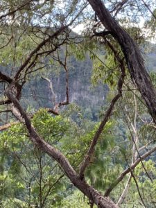
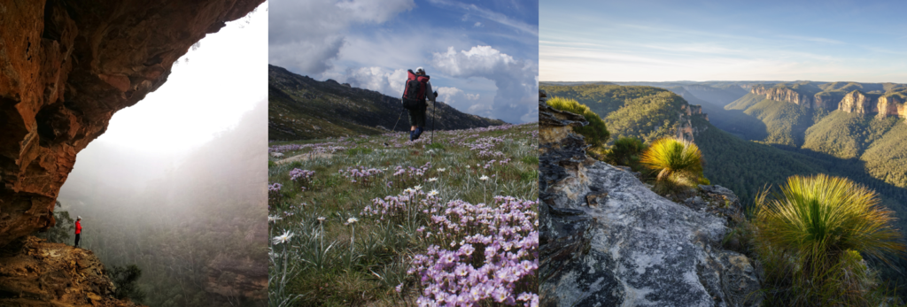
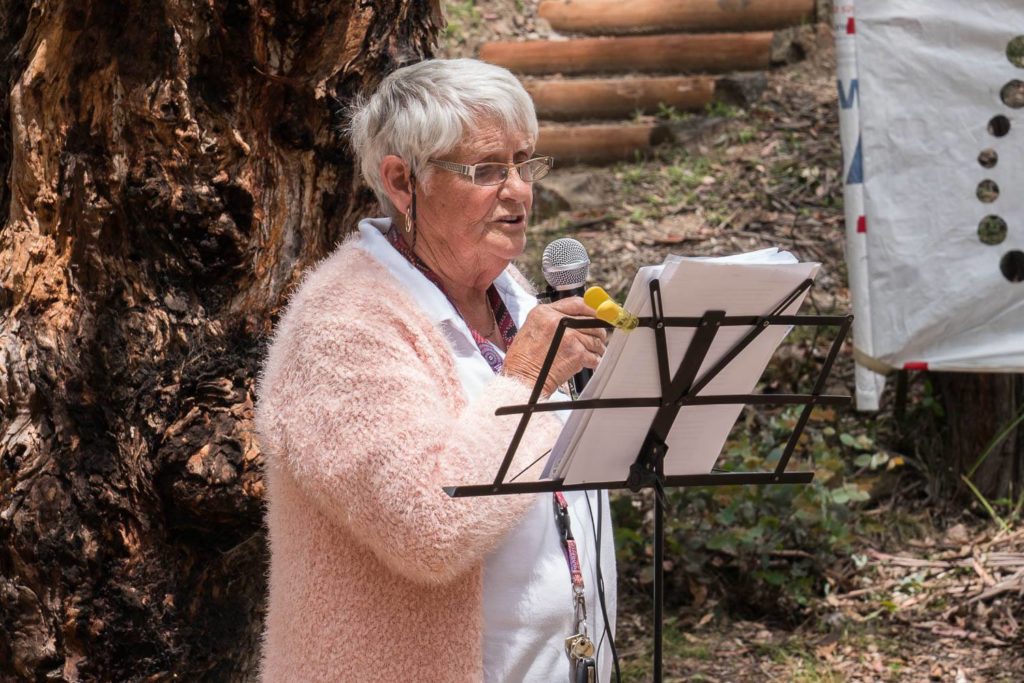
A huge thank you to everyone who entered our photo competition – we have now reviewed the submissions, and we have a few shoutouts to make, as well as the announcement of the winners!
A big thank you to those who included shots of people bushwalking – we love nothing more than seeing you in nature. Additionally, we would like to make a very special mention to the below:
Bruce Lyman who contributed 20 photos, all with great stories to tell
Andrew Stanger who put forward 13 photos of beauty and fun
Andrew Conner who submitted 5 very beautiful photos
Nerida Walkers for her “Young Bushwalker” photo submission!
Our winners are:
3rd place: Peter Cai, Fortress Creek in the Blue Mountains
2nd place: Andrew Stanger, Kosciusko National Park
1st place: Ryan Hansen, Anvil Rock Lookout, Blue Mountains
Trek 100km along Victoria’s Great Ocean Road – join Diabetes NSW & ACT’s adventure of a lifetime!
Trekking along the Great Ocean Road is a life changing experience you will never forget. Explore the diverse and inspiring landscapes as you are awe struck by lush rainforests, deserted beaches, majestic cliff faces and an abundance of local wildlife.
After receiving much positive feedback, the charity leading the adventure, Diabetes NSW & ACT, are very excited to roll it out again for 2019. Celebrating its fifth year this year, the trek covers 100km from Apollo Bay to the Twelve Apostles across Victoria’s rugged coastline. Lace up your hiking boots and join them for this seven day, 100km trek along the Great Ocean Road. Set yourself a challenge for fun, fitness and fundraising. Gail Wright, North Rothbury, was motivated to take on the challenge in 2018. Describing it as one of the best experiences of her life, Gail shared with us a few highlights of the journey. “The views on the trek were phenomenal. Every time we walked a few kilometres the scenery would change, at one point we were trekking through a rainforest, the next through the bush, further along we would pass cliff faces and the ocean and at other times find ourselves amongst rich green rolling hills”, Gail says.
The day commences with breakfast at the award-winning Bimbi Park each morning and then a shuttle to the day’s starting point. Each day is approximately 20km with snack breaks, photo opportunities and lunch. Of an evening the team enjoys hot showers and hearty dinner back at Bimbi Park.
For many of the 2018 GORT team it was more than just spectacular views and physical endurance. It changed their life. As well as floods of memories, many walked away with the motivation to live beyond their comfort zone. The last day was described as “a rush of emotion and joy as we congratulated each other, we felt like a family”.
Participants recalled the enthusiasm from fellow trekkers sharing enthralling stories of what propelled them to get involved in GORT. As a fundraising event, it serves as an incredibly gratifying accomplishment. By taking on the challenge, vital funds are raised to help people living with diabetes.
“I’m happy with my efforts, the money raised, meeting fabulous people and my journey on the walk. Thank you for the opportunity to be involved.” says Gail. She added “ to anyone thinking of walking GORT 2019 I say have a go, you never know what you are capable of until you try!”
Best of all, by taking on the challenge, you will be helping people living with diabetes live a healthier, happier life every step of the way – what could be more fulfilling?
This is a call to member clubs of Bushwalking NSW to nominate an outstanding bushwalker(s) from their club as a potential recipient of this special award of Bushwalking NSW. This award is intended to also raise the profile of that great outdoors activity; bushwalking.
The CHARDON AWARD is intended to recognise particular bushwalkers who have made an exceptional contribution to the bushwalking movement. It is named after Harold Chardon who was the foundation Secretary, in 1932, for “Federation” now known as Bushwalking NSW (BNSW).
CRITERIA: An award to a bushwalker who has made an outstanding contribution, over a number of years, to the NSW and ACT bushwalking movement; hence it must be more than service to just one club of Bushwalking NSW. Deceased members should not be excluded.
The award was first offered in 2017 to Dodie Green of Yarrawood Bushwalking Club and the late Wilf Hilder.
In 2018 the recipients were David Noble of Sydney University Bushwalking Club (SUBW) plus the late Gordon Lee.
NOMINATIONS: Please forward the nomination from your Club for the Chardon Award to the President of Bushwalking NSW, Alex Allchin at president@bushwalkingnsw.org.au
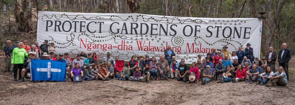
In December 2018 unionists and environmentalists came together to celebrate Joyce Moffitt (1930-1999) and Vern Moffitt (1924-2001) past members of the NPA who were pivotal in establishing NPA’s Bathurst Branch.
The Combined Retired Union Members Association (CRUMA) and the Gardens of Stone Alliance celebrated the installation of the NPWS ‘Moffitts Pagodas’ and highlighted how a Gardens of Stone Stage 2 State Conservation Area would be a win-win for Lithgow workers as it permits the continuation of underground mining; would create a new vibrant tourist economy and protect Lithgow’s internationally significant pagodas and threatened upland swamps; and would protect Lithgow’s internationally significant pagodas and threatened upland swamps.
Retired unionists travelled to Lithgow by train to celebrate the environmental achievements of NPA members Joyce and Vern Moffitt, who were pivotal in establishing the NPA’s Bathurst Branch, in December 2018.
Joyce and Vern Moffitt played a significant role in founding the Lithgow-Bathurst environment movement. Joyce and Vern were founding members of NPA’s Central West Branch, the Bathurst Conservation Group and Central West Environment Council. When Joyce was the Vice President of the Bathurst Conservation Group she wrote submissions opposing underground coal mining on the Newnes Plateau and highlighted the need to protect its rare and endangered Bathurst copper butterfly Paralucia spinifera and upland swamps.
Legendary Combined Retired Union Members Association (CRUMA) member Jack Mundey, former Green Bans BLF (Builders Labourers Federation) Secretary and union champion who saved so much of Sydney’s environment and heritage in the 1970s joined the CRUMA’s delegation to Lithgow in support for the Gardens of Stone Stage 2 Reserve Proposal.
On arrival at Lithgow Railway Station unions and environmentalists marched down the main street of Lithgow carrying their placards, followed by a bite to eat at Lithgow’s Tin Shed Café. There up to 70 other environmentalists, community members, and even the odd coal miner met and listened to speeches that included Aunty Helen Riley, Wiradjuri Elder; David Shoebridge, Greens MLC; Councillor Wayne McAndrew, Lithgow Deputy Mayor; John Koch, Mick Tubbs and Terry Relph, union Elders; and Kathryn Newton, Lithgow Branch of the National Trust.
Former Blue Mountains Mayor Jim Angel, good friend of Joyce and Vern Moffitt, recounted how Joyce and Vern were passionate about protecting the Gardens of Stone and how the celebration was “long overdue”.
Due to difficulties in accessing the ‘Moffitts Pagodas’ NPWS sign in the Gardens of Stone National Park, a replica sign was ‘unveiled’ at Maiyingu Marragu Aboriginal Place.
Newnes Hotel Cabins’ Thomas Ebersoll generously donated the funds to hire a Lithgow Buslines coach to transport the retired unionists to Maiyingu Marragu Aboriginal Place.
Once at Maiyingu Marragu guests enjoyed seeing two impressive 30 metre banners written in Wiradjuri – Nganga-dha walawalag Malang – meaning “Respect for Country and People”.
More speeches were held again at Maiyingu Marragu Aboriginal Place again starting with Aunty Helen Riley, Wiradjuri Elder; followed by Jim Angel, former Blue Mountains Mayor; Bob Debus, former Member for Blue Mountains; and Keith Muir, well respected and long time campaigner for the Gardens of Stone who said that nothing in the Gardens of Stone reserve proposal would threaten Lithgow’s economy and that in time Lithgow would become the new Katoomba.
The replica ‘Moffitts Pagoda’ sign was proudly unveiled by the Moffitt family.
Peter Drinkall, Lithgow poet opened the Maiyingu Marragu ceremony with his song ‘Gardens of Stone’ and then finished the ceremony with his beautiful song ‘Maiyingu Marragu’. Then Aunty Helen invited guests to walk up some steps to see the Wiradjuri people’s treasured, sacred and spectacularly beautiful rock art but to make sure, before their ascent to leave any negativity behind.
Then the retired unionists and guests reboarded the ‘Ebersoll bus’ and headed to the Clwyd of Vale Club where the Vale Ladies Club served a delicious, old fashioned afternoon tea with homemade sandwiches, cakes, slices and plenty of cups of tea. Speeches were made again beginning with the Moffitts’ sons – Michael and Robert – who shared stories of their parents. Michael eloquently described the danger of disunity between workers and environmentalists. Corporations that destroy workers’ rights also destroy environmental rights.
Trish Doyle, MP, Member for Blue Mountains, joined the afternoon tea and acknowledged the important work that unionists past and present had done building positive and constructive bridges between unionists and other environmentalists.
Trish Doyle finished with graciously announcing the winners of the first ever ‘Gingerbread-Pagoda-Houses’ that Retired CFMEU Clelia Koch had spent weeks in the kitchen preparing. Further raffle prizes were donations of a NSW Parliamentary Pack of Wine, overnight accommodation at the Newnes Hotel Cabins and the Fat Wombat Farm Bed & Breakfast.
Returning to the Lithgow railway station, the Lithgow Community Choir farewelled the unionists with songs of coal miners before the train whistle blew telling everyone to board the train.
CRUMA plans to hold a future event in 2019 to celebrate NPA’s Moffitts with the installation of a plaque that highlights their commitment to both Lithgow’s workers and Lithgow’s Gardens of Stone.
Should a small battery tester be considered an essential item of bushwalking equipment? Modern LED torches just keep getting better and better. Battery technology has also gone forward in leaps and bounds with various types that seem to last forever and ever – “best before 20xx”.
My first bushwalking torches used incandescent light bulbs that were miniature versions of house light globes. Like house globes, torch globes had a limited life span so the folklore was always to carry a spare globe. But LED lights are so much brighter from a lamp with an almost infinite life span plus they keep getting better and better. A little while ago the switch on a 100 Lumen head torch failed. The replacement torch under warranty was 160 Lumens. Same model just a few months apart.
Our early torch batteries were the ‘red’ carbon batteries. The Zinc case formed part of the electrical reaction. They would self-discharge in a short time (go flat) often leaving a corrosive mess. The batteries were not very powerful so torches had to be big to hold “C” or “D” (large batteries). Now, alkaline “AA” and “AAA” batteries can be purchased in multi packs. Even better types of battery are available or your choice of rechargeable battery.
Thus, it is easy to keep a light, compact, bright headlight torch that uses small “AAA” batteries at the bottom of the day pack ‘just in case’ – no wandering in the dark from an unexpected delay.
However, since batteries last so long it is easy to forget to check them. Most LED torches have a system of still giving out light as the batteries progressively fail. Corrosion can still eventually happen. So, you turn on your torch in a bright room and you have light but how good is it really?
Such a torch let us down recently at a disused, open access railway tunnel at Helensburgh. This amazing long single-track tunnel was brick lined for reinforcement. The current double track railway through the mountainous terrain has by passed this tunnel. It was dark enough to have impressive glow worms.
Fortunately, a dud torch was not a problem as our group had all taken spare torches. Later at home, I found corrosion had started on one battery. My battery tester indicated that the other batteries were also on the way out.
When did you last properly check your emergency torch? Importantly, when will be your next check? Over time I have seen a range of different battery testers with one thing in common. They were all cheap. There is no reason not to have a battery tester so you can be sure your emergency torch won’t let you down.
The Blue Mountains holds many mysteries, but one is unusual. Among the mysteries are two planes and a memorial plaque. The Blue Mountains have claimed many planes but mostly their crash time AND location is known. Aeroplane Hill in the Blue Labyrinth outside Hazelbrook is the crash site of a then new RAAF Wirraway fighter from a group of four being relocated on 1 August 1940. More recently, in 1993 Bushwalkers Search and Rescue (now Bush Search and Rescue NSW) helped find (deceased) the pilot and passenger from a Cessna that disappeared over the earlier October Long Weekend. CMW bushwalker, Brian Walker saw the wreck on a ridge across a deep valley off the Boyd Plateau (near Kanangra Walls). So, the time AND location of these crash sites are known.
BUT, two planes remain as a mystery. WHEN they crashed is known but their location is NOT known. The United States Marine Corps will be eternally grateful to anyone who could locate the wreck of a Dragon Rapide biplane freighter (and its passengers). Surprisingly, many of these planes were still constructed in WWII and continued in service post WWII. On 17 April 1943 two US Marines were passengers on a Dragon that was seen to be in trouble in the lower Blue Mountains. Again, on 22 October 1954 Max Hazelton came back from the dead when he walked into a Post Office now covered by water of Warragamba Dam. He had survived a crash and a six day walk from the Kanangra Walls area. Max later established the regional Hazelton Airlines. In 2014 Dick Smith and Max unsuccessfully tried to locate his crash site. Thus, the time BUT not the location of these aircraft crashes is known.
What about a different mystery where the LOCATION is known but NOT when and why?? The location of a memorial to a WWII Battalion is known but little else.
Splendour Rock at the southern end of Mt Dingo in the Megalong Valley is an outstanding location to remember bushwalkers who died in the armed services of WWII. From Sydney Bush Walkers (SBW) records we know the names of the first bushwalkers to see this site and when its fabulous memorial was installed in 1948. “The Bushwalker” archives at www.bushwalkingnsw.org.au describe the dedication service, led by Paddy Pallin, on ANZAC Day 1948. For many recent years there has been a simple memorial service each ANZAC Day at Splendour Rock. All bushwalkers should consider attending this moving service with its dry overnight camp at least once.
So, not only do we know the location and time of dedication of the Splendour Rock plaque but the names of the fallen bushwalkers we remember each year. In 2014 the NSW State Library eagerly accepted the nomination, by the author, of Splendour Rock for their register of NSW War Memorials; see www.warmemorialsregister.nsw.gov.au/content/bushwalkers-war-memorial-splendour-rock
Very few at Splendour Rock would know where to look for a much smaller memorial to 2/17th Battalion of the WWII A.I.F. (The ‘second’ Australian Imperial Force; A.I.F. was the Australian Army of WWII). Why was this plaque installed to remember “MATES” of just one of many battalions of one of several Divisions raised in WWII? Information from the Australian War Memorial (AWM) shows that during WWII the size of a battalion was modified but was still less than 800 men.
Just to the west of Splendour Rock is a small south facing wall. Location for this plaque must have been more important than access as you need to scramble over a large boulder then look up. The plaque is above your natural eye height. Who were the “MATES”? Some only or all the infantrymen of this particular Battalion? Author, Michael Keats is more than 90% certain that bushwalking historian, Wilf Hilder (deceased) told him that Gordon Broom installed this plaque. Now, from National Australian Archives we know a Gordon Broome served in the 2/17th Battalion. Much later he was a member of Sydney Bush Walkers (SBW).
Thus, here is the mystery. We know the location of a memorial plaque to ‘MATES’ possibly installed by Gordon Broome BUT not when and why. Since it is near the Splendour Rock plaque, which was dedicated in 1948, this ‘MATES’ plaque should be post 1948. Many lines of inquiry have failed to provide further information.
SBW records cannot offer any further information. The family are not keen to be contacted. The 2/17th Battalion Association (BA) is mostly made up of ex-servicemen post WWII who trained prior to disbanding the Battalion in 1946. The few very old hands still alive from WWII cannot help with this mystery.
Wilf Hilder knew much about the Blue Mountains, but we can no longer ask him. An important logbook would seem to have been lost in a fire of Paddy Pallin’s shop around 1970. An entry from a 1958 logbook in the NSW State Library mentions that an earlier logbook was passed onto Paddy Pallin. The Paddy Pallin archives have no mention of this ‘MATES’ plaque. Bushwalking NSW has incomplete records of old “Bushwalker” annuals / magazines on their website. Equally, there seem to be no records of the names of the 140 bushwalkers who attended the 1948 dedication.
However, Gordon’s name does appear many times in campaigns from North Africa to New Guinea of the official history of the 2/17th Battalion (plus a privately published history of “B” Company). He did not escape injury being wounded during close combat in New Guinea. Is Gordon remembering the ‘MATES’ who helped him survive but also mindful of other mates who could not be helped?
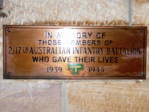
For many years post WWII Gordon was active in the BA social sub-committee. In 1953 he also joined a sub-committee to add a further memorial to those of the 17th Battalion (from WWI) at St Thomas Church, North Sydney. Eventually in 1956 a plaque was installed with the words; “IN MEMORY OF THOSE MEMBERS OF 2/17th INFANTRY BATTALION WHO GAVE THEIR LIVES 1939.1945″. The BA still have a service of remembrance each year on the Sunday before ANZAC Day. Could the “MATES” plaque at Splendour Rock have also been installed around this time?
So, why is this “MATES” plaque at this particular orientation? Small trees have now grown up but it would seem that the plaque has been placed, up high, to follow the sun from sunrise to sunset of “The Ode”, “… At the going down of the sun, and in the morning, We will remember them…”
Can we be sure of any emblems on this plaque? There can be no doubt that the shallow “T” in the top centre is the ‘T for Tobruk’ award that can only be shown by Battalions who took part in this terrible siege of 1941 in North Africa. (The encircled troops still took the fight up to the German “Afrika Korps”. The repulse of the Easter 1941 attack may have been the first defeat of a ‘blitzkrieg’ attack.)
The importance of the diamond emblems can only be guessed at since the logic of Gordon Broome remains unknown. While the colours must have been very deliberately chosen there are two possible explanations. Information from the AWM suggests that the black over green are the colours of the (WWI) 17th Battalion while brown over red applied to the (WWI) 23rd Battalion. Now, both the 2/17th and 2/23rd Battalions were part of the Tobruk siege but why mention the 2/23rd when records also show close liaison between the 2/17th and 2/13rd Battalions in this siege. OR do the diamonds apply to liaison between battalions in the later New Guinea campaign?
An alternative suggestion from a member of the BA is that the 2/17th Battalion used the black over green diamond until they sailed to North Africa when the brown over red diamond was adopted. The problem is that battalion diamonds from WWII have a narrow grey border. Either way this plaque would have required some planning and expense. There is no maker’s mark on this plaque. The high position of this plague at Splendour Rock suggests that its installation may have required two or more bushwalkers. Perhaps the mystery is a deliberate act so we should just remember the many ‘MATES’ of the 2 A.I.F. who did not return.
So, the mystery at Splendour Rock seems to endure as on another ANZAC morn the sun slowly rises again over the distant Kings Tableland to stab the valleys with shafts of sunlight. Cloud hides the water of Lake Burragorang. The memorial calls us to remember the fallen but leaves us to seek out their names. The same sun starts to light up the ‘MATES’ plaque; lest we forget. Does it matter that we don’t understand the full mystery? The plaque was not put there for you or me but by fellow mates. You should, like the author, now seek out this “MATES” plaque each time you visit Splendour Rock to stand in silent respect and wonder at the strength of friendship plus dedication required to remember ‘MATES’ at this remote location.
Select the ‘Set the Private upload’ option and click the orange ‘Upload’ button
Copy and paste the bold link created into an email to newsletter@bushwalkingnsw.org.au with your full name, location, and image name
Here are the prizes to be won courtesy of Paddy Pallin:
1 x Osprey Trillium Duffel Bag
1 x Osprey Map Wrap
1 x Patagonia Cap
1 x Copy of the book ‘Swell’ by Liz Clark
1 x Paddy Pallin Nalgene Bottle
1 x Matt Neck Scarf
We look forward to seeing your photos!
Please note that by submitting photographs to this competition, you acknowledge that:
you possess copyright to the images,
that you give Bushwalking NSW permission to use the images you supply in any Bushwalking NSW website, newsletter, social media, email, online and printed publications without attribution, and
you warrant that Bushwalking NSW will not infringe any copyright by using the images you have supplied in any way.
Thank you for sharing the beauty of our bushland with the world!
The Sydney Morning Herald (SMH) of 31 December 2018 has a worrying report of two deaths from Tiger Snake bite. Antivenom was administered but it would seem that the dose was insufficient to counteract the snake venom. The SMH article suggests that there may be disagreement within the medical profession regarding the guidelines for the correct dose of antivenom; just how much antivenom is an appropriate dose of the latest type of antivenom. However, there is a call for more research in this matter that has been echoed by the Victorian Coroner.
Any snake bite victim needs to seen promptly by medical services. Despite this SMH report death from snake bite is now rare with modern antivenom.
Now since snakes are more likely to be active in the recent warm weather bushwalkers need to be more vigilant than usual and consider protective measures such as wearing gaiters or long trousers. As always, it is better to never get bitten but never forget your First Aid training for the treatment of snake bite. The necessary broad bandage needs to be easily accessible such as near the top of your rucksack.
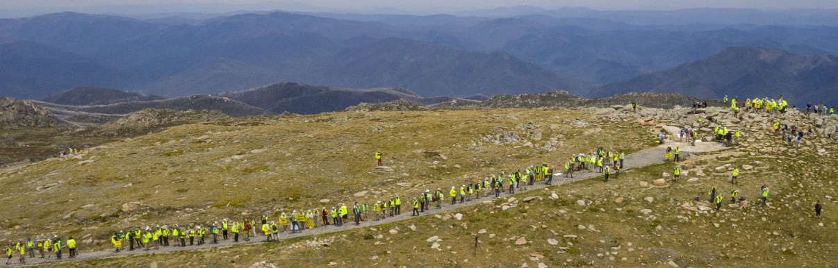
Most of the 200 Save Kosci walkers at the summit of Mt Kosciuszko
The Save Kosci walk ended on Saturday with amazing scenes as around two hundred walkers arrived at Rawsons Pass and headed to the summit of Mt Kosciuszko. The Save Kosci hired helicopter carrying Channel 7 and the Canberra Times circled the summit several times while we chanted ‘It’s a Park not a paddock’ and excitedly waved our arms off. The helicopter then took the media on a tour of undamaged and severely-damaged sites in the national park.
To reduce pressure on the alpine vegetation near the summit, we returned to the paved area at Rawsons Pass, where Andrew Cox, CEO of the Invasive Species Council, presented certificates to the five full-distance walkers – Marg Sharp, Alan Laird, Tom Vaughan, Paul Millgate and Donna Powell. And kindly gave me a thank-you certificate as well.
Sympathetic newspaper articles – in the Weekend Australian, the Canberra Times, the online editions of the SMH and Brisbane Times, and in the Guardian – and an interview on ABC Radio South East, were triggered by the last day of the walk. A Channel 7 feature is still in preparation and will air in January.
Thanks to the amazing support from our communities, the Save Kosci walk has achieved many things:
The 2 weeks of the walk through the electorate of Mr Barilaro indicated that the majority of Monaro voters support Save Kosci’s aims. Although there were a few negative comments on social media and from passers-by, the vast majority of reactions were very positive. They ranged from thumbs-up from passing cars to home-made cakes. The promised confrontations and ‘you’ll be run out of town’ comments on some social media sites did not lead to anything.
The numbers at the protest in Queanbeyan on 22nd November – nearly 150 of us and just 17 brumby advocates – were further evidence that Save Kosci represents a majority view.
Media coverage has been extensive, especially in regional media, thanks to the work of Cynthia Burton. The list at the foot of this post relates to coverage triggered by the Save Kosci walk; other excellent coverage from releases issued by our umbrella organisation, Reclaim Kosci, on horses starving from over-population and on the November 8th science conference, ensured that the issue of feral horse damage in Kosciuszko National Park (KNP) has been repeatedly in the news
We have had a lively presence on Facebook and Twitter, thanks to Terrylea Reynolds and Cynthia Burton
Because of the walk, we were able to put our case face-to-face to influential people including Penny Sharpe (Deputy Leader of the NSW Labor Party), Mike Kelly (member for the federal seat of Eden-Monaro), Anoulack Chanthivong (member for the state seat of Macquarie Fields), Greg Warren (member for the state seat of Campbelltown), Sally Quinnell (Labor candidate for the state seat of Camden), Ursula Stephens (Labor candidate for the state seat of Goulburn), Bryce Wilson and Peter Marshall (Labor and Greens candidates for the state seat of Monaro), John Castellari (Councillor Snowy-Monaro Regional Council), Pru Goward, member for the state seat of Goulburn, Tim de Mestre (National Party Member and former Chair of Chairs of the Local Land Services Board) and Tara Cheyne (MLA, ACT)
We were welcomed to country by Indigenous elders Wally Bell (Ngunnawal) and Aunty Deanna (Ngarigo); Uncle Max Harrison (Yuin) attended the start of the walk and we also had supportive contact with the Wingecarribee Aboriginal Community & Cultural Centre.
We have nearly 1000 signatures on our petition to the state parliament of NSW; a good start towards our aim of 10,000 signatures by end of March 2019.
The walkers have forged new friendships, and once the blisters heal, will have many happy memories. Many ‘quiet bushwalkers’ have discovered environmental activism.
What’s next?
Now that the Save Kosci walk has successfully concluded, the focus is shifting to raising awareness of the feral horse issue prior to the NSW elections, and to the paper petition. (The NSW Parliament does not accept electronic petitions.)
I am looking for volunteers willing to help get petition signatures, through fellow club members and friends and/or staffing petition-signing tables at local shopping centres. Please contact me if you can help: lbgroom@gmail.com or 0473 919 441
Reclaim Kosci will also continue the campaign through their website and on Facebook.
THANK YOU ALL! The full distance and longer-distance walkers have been overwhelmed by your support.
Linda Groom
Convenor, Save Kosci Inc
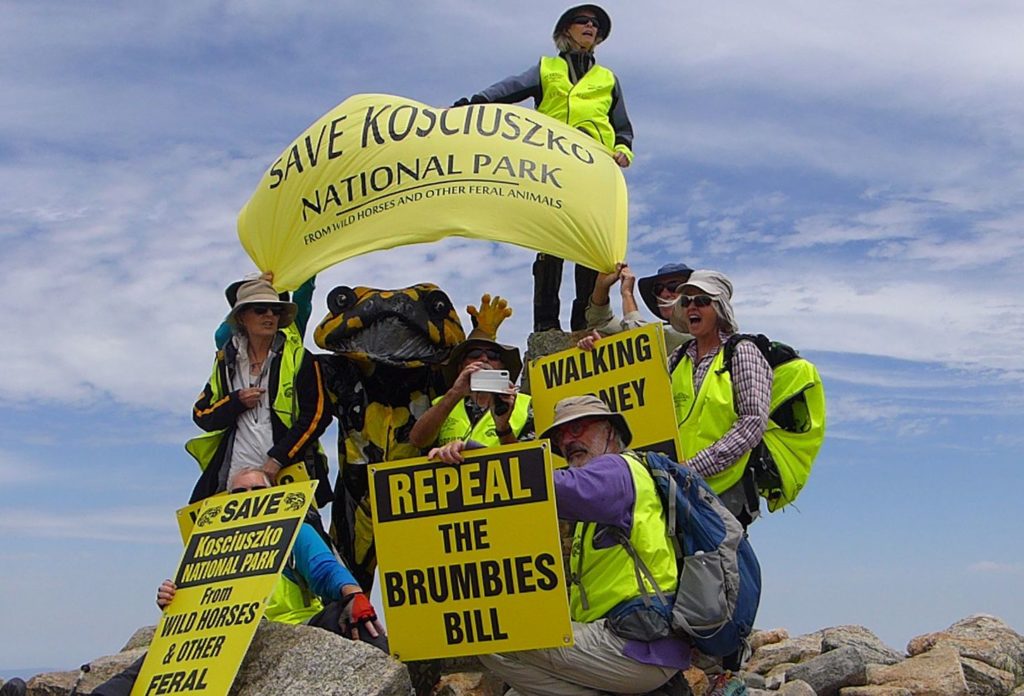
Linda Groom, Corroboree frog, and Save Kosci through walkers on the summit of Mt Kosciuszko
***********
Media coverage included:
19 November
Queanbeyan Age/Chronicle:
Brett McNamara article with direct reference/link to Save Kosci –
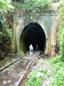 Such a torch let us down recently at a disused, open access railway tunnel at Helensburgh. This amazing long single-track tunnel was brick lined for reinforcement. The current double track railway through the mountainous terrain has by passed this tunnel. It was dark enough to have impressive glow worms.
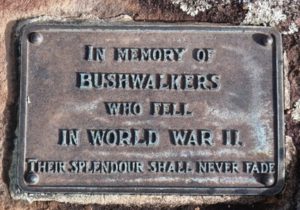 Splendour Rock at the southern end of Mt Dingo in the Megalong Valley is an outstanding location to remember bushwalkers who died in the armed services of WWII. From Sydney Bush Walkers (SBW) records we know the names of the first bushwalkers to see this site and when its fabulous memorial was installed in 1948. “The Bushwalker” archives at
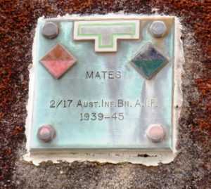
 For many years post WWII Gordon was active in the BA social sub-committee. In 1953 he also joined a sub-committee to add a further memorial to those of the 17th Battalion (from WWI) at St Thomas Church, North Sydney. Eventually in 1956 a plaque was installed with the words; “IN MEMORY OF THOSE MEMBERS OF 2/17th INFANTRY BATTALION WHO GAVE THEIR LIVES 1939.1945″. The BA still have a service of remembrance each year on the Sunday before ANZAC Day. Could the “MATES” plaque at Splendour Rock have also been installed around this time?